
Do you remember Pokémon Go? At its peak, the game prompted millions of people around the world to walk city streets in search of Pokémon using their smartphones. Its popularity was significant enough that, in 2025, Saudi Arabia’s Savvy Games Group acquired the gaming division of Niantic for $3.5 billion. Although the game no longer receives the same level of attention as it once did, it appears to remain widely used. As it turns out, data generated through the game has found applications in a rather unexpected field.
In 2020, Niantic introduced AR Mapping Tasks for Pokémon Go, followed in 2021 by the launch of the Powered-Up PokéStops feature. This system allowed players to collaborate on augmented reality mapping tasks and create new AR experiences by scanning real-world PokéStop locations with their smartphones.

At first glance, this appears to be a typical gameplay mechanic. However, according to DroneXL, in December 2025, Niantic Spatial entered into a partnership with Vantor to develop an integrated positioning solution for aerial and ground platforms. The system is designed to enable navigation and coordination in environments where GPS signals are unavailable. It is based on AI models that were trained, in part, using data collected through Pokémon Go.
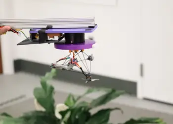
Traditional GPS systems rely on satellite signals, and virtually all modern military navigation and guidance systems depend on GPS to function. Disrupting access to GPS remains one of the most effective ways to impair an opponent’s operational capabilities. This is where Visual Positioning Systems (VPS) become relevant, providing navigation capabilities even when satellite signals are unavailable. Such technologies have applications across multiple industries, but Vantor’s software is currently used in military drones, making defense-related applications a primary focus for the company.
At first glance, this appears to be a typical gameplay mechanic. However, according to DroneXL, in December 2025, Niantic Spatial entered into a partnership with Vantor to develop an integrated positioning solution for aerial and ground platforms. The system is designed to enable navigation and coordination in environments where GPS signals are unavailable. It is based on AI models that were trained, in part, using data collected through Pokémon Go.
Traditional GPS systems rely on satellite signals, and virtually all modern military navigation and guidance systems depend on GPS to function. Disrupting access to GPS remains one of the most effective ways to impair an opponent’s operational capabilities. This is where Visual Positioning Systems (VPS) become relevant, providing navigation capabilities even when satellite signals are unavailable. Such technologies have applications across multiple industries, but Vantor’s software is currently used in military drones, making defense-related applications a primary focus for the company.
At the same time, Pokémon Go data is not being used to directly map or operate the system. In a statement to PC Gamer, representatives of Niantic Spatial explained that the “ground scans” collected through Pokémon Go are only one of several data sources used to train AI models. The company also clarified that its agreement with Vantor does not involve sharing those scans. Furthermore, following the acquisition of Niantic’s gaming business by Scopely, Niantic Spatial no longer has access to scan data gathered through the game.
Vantor stated that it is “exploring the possibility of adapting Niantic Spatial’s ground-based visual positioning system” for use with its own solutions, but does not have access to actual Pokémon Go data. “Vantor’s GPS-denied localization capabilities are based on our own 3D datasets, which are generated from satellite imagery,” the company said.
According to Jeroen van den Hoven, it is difficult to determine the exact role that Pokémon Go data played in training Niantic Spatial’s AI systems, given the scale of the dataset, which reportedly includes nearly 30 billion scans. However, he argues that the impact was likely significant, as such a large volume of scans would have accelerated the development process.
The collection of this data is covered by Pokémon Go’s terms of service. Sections governing user-generated and AR-related content state that users grant Niantic a non-exclusive, transferable, multi-tier sublicensable, worldwide, royalty-free, and perpetual license to use collected data and scans. Van den Hoven also noted that companies “do not necessarily use our data to improve people’s lives in a meaningful way, such as through education. The goal is to make money.”
Read also:
- Middle Strike: How Ukraine Is Building a New Class of Medium-Range Strike Systems
- Hunting Shahed: Ukrainian drones receive a unique autonomous interception system
Source: pcgamer


